


Ship Radar - Ship Positions

Ship Radar - Ship Positions açıklaması
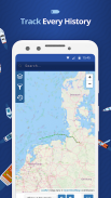
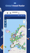
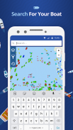
🌟 All vessels live on a map 🌟
➡️ You have the option to choose between 4 map types: Standard map, Simple map, Satellite map or OpenStreetMap
➡️ Every vessel type is marked in a specific color
➡️ You can explore plenty of different vessel types: Fish carriers, Crude Oil Tankers, Fishing Vessels, Other Tugs / Special Crafts, Bulk Carriers, Fire Fighting Vessels, Service Vessels, Passenger Ships, Training Ships, Yachts and much, much more
➡️ Besides vessels, the map contains ports and other locations
🌟 Search option 🌟
➡️You also have the option to search for specific vessels by IMO number or MMSI, ports, seas or other locations.
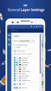
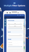
🌟 Filter option 🌟
➡️Sort out specific vessel types, so that you only get to see what you want to see.
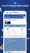
🌟 Vessel information 🌟
➡️ Get various pieces of vessel information by tapping on a vessel symbol such as speed, course and current status. You also get to see a picture of each vessel.
How does it work?
---------------------------------
We are using AIS data to provide you most accurate information. If you want to track vessels you just have to tap on "Start ship radar"
🌟 Tüm gemiler bir harita üzerinde canlı 🌟
Standart harita, Basit harita, uydu haritası veya OpenStreetMap: ➡️ Sen 4 harita türleri arasında seçim yapma imkanına sahip
➡️ Her gemi tipi, belirli bir renkte işaretlenir
➡️ Farklı gemi tipleri bol keşfedebilirsiniz: Balık taşıyıcılar, Ham petrol tankerleri, Balıkçı teknelerinin, Diğer Römorkörler / Özel El Sanatları, Toplu Taşıyıcılar, Yangın çok daha Gemiler, Servis, yolcu gemisi, Eğitim Gemi, Yat ve daha fazlası, Mücadele
➡️ gemilerin yanı sıra, harita liman ve diğer konum içeriyor
🌟 Arama seçeneği 🌟
➡️You da IMO numarası veya MMSI, limanlar, denizler veya diğer yerlere göre belirli gemiler için arama seçeneğine sahip.
🌟 Filtre seçeneği 🌟
Yalnızca görmek istediğiniz ne olduğunu görmek için olsun, böylece belirli damar türlerini ➡️Sort.
🌟 Gemi bilgisi 🌟
Böyle hız, kurs ve mevcut durum olarak bir gemi simgesine dokunarak damar çeşitli bilgileri alın ➡️. Ayrıca her geminin bir resmini görmek için olsun.
O nasıl çalışır?
---------------------------------
Size en doğru bilgi sağlamak için AIS verilerini kullanıyor. Eğer damarları izlemek istiyorsanız sadece "Başlat gemi radar" dokunun zorunda
Ship Radar - Ship Positions - Sürüm 1.1.9
(15-12-2020)
Ship Radar - Ship Positions - APK Bilgisi
APK sürümü: 1.1.9Paket: com.sawischa.shipfinderShip Radar - Ship Positions uygulamasının en son sürümü
Diğer sürümler


Aynı kategorideki uygulamalar


